Getting Here
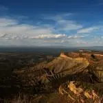
The canyon is located in southwest Colorado, about 265 miles from Denver. The closest towns are Montrose (14 miles) and Gunnison (63 miles). Both have airports and offer an ample selection of hotels. The canyon has two access points, on the south and north rims. There is no bridge across the canyon, so allow 2 to 3 hours if you want to drive around from one rim to the other. The road along the north rim is gravel, with only one accessible restroom (North Rim Ranger Station) and one accessible overlook at Sunset View. The south rim has much more to offer the disabled traveler, so I am going to focus on the attractions on the south rim in this article. To reach the south rim: From Montrose or Gunnison, take US-50 to CO County 347 and proceed north to the park entrance. The entrance to the north rim is 11 miles southwest of Crawford, CO: From CO Highway 92, 3 miles south of Crawford turn west on Black Canyon Rd. and follow signs.
Travel Tips
This is a high-elevation area. Be alert for symptoms of altitude sickness. Go slow and drink plenty of water. The sun will be intense at this elevation regardless of the time of year or temperature; be prepared with a hat, sunglasses, and sunscreen. I visited in early July when the temperature was in the 70s but it felt much hotter. There is no food service at this park. Bring your food and plenty of water. This is a remote area with variations in elevation so cellular service is likely to be unreliable.
South Rim Access
Stop at the entrance station to pay the fee (charged per vehicle, or show Access Passport) and obtain a map. South Rim Road begins here and is an 8-mile long (one-way) scenic drive with beautiful views of the canyon and 12 overlooks. Some are close to the road and others require hiking a trail. Past the South Rim Campground, the first viewpoint you will reach is Tomichi Point on the right. There is handicapped parking and a short sidewalk to an accessible viewing platform. Next, you will come to the South Rim Visitor Center just a short distance down the road. This new log building is fully accessible with parking and restrooms and offers a film, exhibits, and park information. There is a large wooden deck on the back of the building that overlooks the canyon. There are also some trails here but they are not wheelchair-friendly.
Continuing along South Rim Road, you will come to Pulpit Rock Overlook. There is handicapped parking along the road at this picnic area, and there is an accessible restroom beside the road, but I did not find the picnic area and overlook to be wheelchair accessible; no ramp or paved access and the ground was rough and uneven. The next three features along the road are trailheads at Cross Fissures View, Rock Point, and Devil’s Lookout. These trails are approximately 1/2 mile one-way and not accessible but may be at least partially useable by some with assistance. The dirt and rock surfaces were hard-packed but had rough spots and some grades. My husband hiked two of these and said it was not necessary to attempt these trails because the views were no different from what was visible at the accessible points.
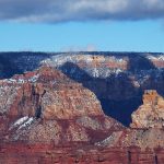
A mile or so past Devil’s Lookout trailhead, you will come to Chasm View. This spot has accessible parking and a short, hard-surface trail to a wooden viewing platform that hangs you right over the canyon! You can see the famous “Painted Wall” from here, so it is not necessary to stop at the next 2 inaccessible trails at Cedar Point and Dragon Point. Drive on instead a couple of miles further to Sunset View Picnic Area where there is a jaw-dropping view as well as accessible parking, picnic tables, and restrooms. The South Rim Road ends with a turn-around loop at High Point. This area offers more accessible parking, picnic tables, and restrooms, but the Warner Point Trail is not accessible.
If you have enough time and would like to see more, you can access the Gunnison River. First, return to the park entrance station. From there, you can either take the steep, windy East Portal Road (8-10 miles one-way, 16% grades, no vehicles >22′) down to the riverbed or exit the park and drive east 18 miles on US-50 to Cimarron, where there is a railroad exhibit and view of Morrow Point Dam.
Camping
If you’d like to camp, the South Rim Campground just inside the national park entrance offers 2 accessible sites (A21 and B21) and restrooms. Reservations can be made online but must be made at least 3 days in advance. There is a camping fee, with a discount for Access Pass holders. Also, several campgrounds are available around Blue Mesa Reservoir in the Curecanti National Recreation Area to the east of Black Canyon on US-50. Lake Fork Campground is described as most suitable for visitors with disabilities. This is also a very scenic area that I highly recommend if you can add it to your itinerary.

