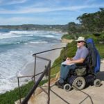
This rocky, forested headland in the Monterey Bay was named Point Lobos in the late 18th century, for the sea lions (lobos marinos, “sea wolves”) whom Spanish settlers heard barking on offshore rocks. Hundreds of them live here almost year-round, between August and June. Also look for harbor seals hauled out on the rocky shorelines of the Point’s many coves, for otters in the kelp beds offshore, and white-crowned sparrows nesting in coastal scrub vegetation. All are protected within this state reserve, as are the Monterey cypress trees, rare native stands of Monterey pine, other rare plant communities, and some archeological sites. Gray whales pass by on their migration from December through April. A limited number of cars are allowed, so arrive early to avoid waiting in line. No reservations.
Visitor Center: A small outdoor area at Cypress Grove has exhibits on the history and natural features of the park. When staffed, docents display artifacts and answer questions.
Sand Hill/Sea Lion Point Trail
see access criteria for definitions
Trailhead: 200 feet beyond the Sea Lion Point lot
Length: Under one mile total
Typical Width: 4 ft. & above
Typical Grade: Level
Terrain: Firm
Obstacles: During our visit in April, poison oak lining the trail slowed me down.
Description
As you follow this short trail along a blufftop through chaparral, you can see waves crashing on the rocks 50 feet below. A wood railing that runs along Sand Hill Trail may obscure views for some wheelchair riders. During our visit in springtime, two sea lions were cavorting in the waves that washed up on a little beach, and an otter floating below devoured a sea star. Many wildflowers were blooming. Benches are at frequent intervals. In about .25 miles, the trail ends at a junction with the Sea Lion Point Trail; turn right to loop back to the parking lot.
Cypress Grove
see access criteria for definitions
Trailhead: Cypress Grove lot
Length: Under one mile total
Typical Width: less than 30 in.
Both sides of the loop are less than three feet wide and have short slopes exacerbated by drainage bars as much as three inches high. Some stretches have cross-slopes.
Typical Grade: Gentle
Terrain: Firm
Obstacles: About halfway from the start of the loop, stairs prevent wheelchair riders from completing the circuit.
Description
Carmel Bay and the Monterey peninsula are visible from this .75-mile loop trail, which skirts the perimeter of Point Lobos’ windswept northernmost peninsula. The entire trail winds through the Monterey cypress forest—one of only two naturally growing stands remaining in the world. The trail starts wide and mostly level, then splits after about .25 miles to encircle Allan Memorial Grove, named for A.M. Allan, who saved Point Lobos from development by buying it in 1898 and selling it to the State 35 years later. Most wheelchair riders will only be able to continue a few hundred yards on either side of the loop; on both sides, the trail narrows to less than three feet and has slopes. In my power wheelchair and with some assistance, I completed each side of the loop and was rewarded with spectacular views of surf on rocks, nearby crags overgrown with chaparral, wildflowers, and weathered cypress. Since a stairway bisects the loop, each time I had to backtrack. Benches are provided.
Bird Island Trail
see access criteria for definitions
Trailhead: Southernmost parking lot
Length: Under one mile total
Typical Width: 4 ft. & above
Typical Grade: Gentle
Terrain: Firm
Description
Bird Island Trail climbs gently through coastal scrub on a cliff between woods and sea, with continuous stunning vistas. From the parking lot a set of stairs ascends to the trail, but to the right of the stairs is an accessible, gently switchbacked incline. Shortly after the crest, just after you round the bend, the sparkling jade-green waters and small white-sand beach of China Cove come into view. Here you’ll likely see sea otters resting in kelp and harbor seals hauled out on rocks. We could even see seals swimming in the shallow, clear waters; caves in the rock were also visible. An abundance of wildflowers blanketed the cliffs on our early June visit, including monkeyflower, lupines, yellow bracts, and many others I didn’t know. Poison oak was also prolific.
The trail briefly turns inland before you reach Gibson Beach (both it and China Cove are accessed via long staircases). You cross a bridge that’s about three feet above an eroded area ––be sure to admire the views of the beach and the impressive homes built into the hillsides. After the bridge are several places with steep drop-offs and no protective edge along the trail, but these stretches are fairly level and it wasn’t too unnerving. After less than a quarter of a mile, the trail ends at a short loop trail that affords close-up views of hundreds of Brandt’s cormorants nesting on the aptly named Bird Island. Be advised that the guano can be very pungent.
Accessibility Details
The facilities listed below meet all of our access criteria unless otherwise noted.
Accessible Visitor Center: Yes
Accessible Parking: Yes
At Bird Island Trail, Sand Hill Trail, and Piney Woods picnic area. A small lot at Whalers Cove has a designated accessible space that is not stripped. When the lot is full, which is often, it may be difficult to lower a lift.
Accessible Restroom: Yes
At Piney Woods, Sand Hill, Whaler’s Cove, and Bird Island Trail
Accessible Picnic Tables: Yes
At Piney Woods and Whalers Cove. Piney Woods picnic area is somewhat sheltered from the wind but has no ocean views.
Other Things of Interest
Close to the water and just a few feet above sea level, the picnic area at sheltered Whalers Cove is a great place to watch seals and otters and listen to waves slosh ashore.
Additional Information
Hours: Park is open from 8 am to a half-hour after sunset and the visitor center is open daily, 9 am-5 pm, as staffing permits
Map: See here.
Fees: Entrance
Dogs: Not allowed.
Last updated on June 10, 2023
I has worked for more than 30 years advocating for, and educating about access to outdoor recreation and tourism for people with disabilities. I hold a degree in Recreation Therapy and was a travel agent specializing in accessible travel for many years. In this capacity, and now as Associate Director at Wheelchair Traveling, I consult with the travel industry about accessibility, conducts disability awareness trainings and writes about travel and outdoor recreation. I also authored a book titled, A Wheelchair Rider's Guide: San Francisco Bay and the Nearby Coast, about accessible trails and has produced several access guides to San Francisco. My most current project is a website of accessible trails along the entire California Coast (www.wheelingcalscoast.org). My extensive experience as a wheelchair rider combined with her professional experience has provided me with in-depth knowledge about inclusive tourism and outdoor recreation.