The grouping of four towering sequoia redwoods alongside the road in the Sierra Mountains, known as the “Four Guardsmen,” is usually the first stop for visitors when approaching the two parks. Vehicles scurry to find a place to park alongside the road, but I fly right by them knowing this is only the beginning, and that there is much more to see by wheelchair at both Sequoia National Park and the neighboring Kings Canyon National Park.
Sequoia National Park
Tunnel Rock is the historical marker to indicate that you have arrived in Sequoia National Park, located off Highway 198 from the small town of Three Rivers. When the park was established in 1890, a section of this road was blocked by an enormous rock, so it was chiseled out to allow people to pass and named Tunnel Rock. The road has been diverted around the rock, but visitors are welcome to get out of their vehicles for a closer look. A couple of points of interest are along the way, such as Hospital Rock and the Foothills Visitor Center, before the road climbs up the mountain in an intense switchback, carved out of the hillside to originally accommodate wagons and carriages.
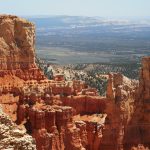
The Giant Forest is one of two main areas of Sequoia National Park and is where the General Sherman Tree still stands, the largest known tree measured by volume. The tree was named after William Tecumseh Sherman, a prominent and well-educated man who succeeded Ulysses S. Grant when he took the presidency following the Civil War. From the designated accessible parking space and shuttle stop, the paved trail is less than 0.2 miles with very little grade change to the base of the tree. The trail inclines slightly to loop completely around the tree. A side trail goes up to a viewing platform and ends at stairs that lead to the general parking lot.
Another trail that goes off from the General Sherman Tree is the Congress Trail, one of my favorites. This trail is fully paved but with several inclines, so wheelchairs with power assistance will favor better. The time is worth it as the trail loops around dozens of Giant Sequoias, including the Lincoln Tree, Washington Tree, General Lee Tree, and of course clusters of trees known as the Senate and another as the House; the President Tree is also nearby.
Across from the Giant Forest Museum and Sentinel Tree, many wheelchair visitors will enjoy hiking the Big Trees Trail around Round Meadow. This trail was modified to be level and firm, and during the spring and early fall, the foliage is particularly scenic. The Beetle Rock Trail is just south of the museum and leads out to a large rock that resembles a beetle’s back. I found I was able to climb this rock to some degree, with caution, in both a manual and a power wheelchair. The thrill of a climb was exhilarating enough, and the epic view at sunset made it all that more worth it. The trail itself is a paved half-circle with a couple of inclines.
Everyone should take a drive on Moro Rock/Crescent Meadow Road, a road that splits off just behind Giant Museum. Enter into a waterfall of ferns, as if the Giant Sequoias were not breathtaking enough, and drive alongside Moro Rock by the Roosevelt Tree. Drive through a tree at Tunnel Log on the way to Crescent Meadow and Tharp’s Log Cabin, just be mindful of other vehicles.
Kings Canyon National Park
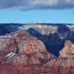
Kings Canyon National Park is just north of Sequoia National Park in the Sierra Mountains, so about an hour away from the Giant Forest is Grant Grove, home to the General Grant Tree, also known as the Nation’s Christmas Tree proclaimed by President Calvin Coolidge in 1926. This tree is the second largest behind General Sherman and was given this name in honor of the 18th president, Ulysses S. Grant. Another scenic area of Grant Grove is the Panoramic Point which climbs up a paved trail to a platform overlooking the Sierra Mountains. Two additional overlooks are on either side of the Generals Highway a few miles from the Kings Canyon Visitor Center and Grant Grove Village.
Beyond Grant Grove, the forest begins to diminish in the High Sierras due to natural elements and the aftermath of recent wildfires. Despite the scorched earth, the land remains fertile and alive with life. Streams run down the thirsty rocks, at times merging into falls, circulating rich minerals into the Kings River. Tree saplings spring out of rock cracks derived from ancient roots stronger than ever. The crackling rocks protrude from the mountainside like a jagged knife and flake off like layers of old skin. This is Kings Canyon, much of which is under the land management of Sequoia National Forest.
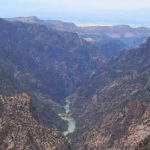
Only a couple of designated overlooks exist along Kings Canyon, though there are several places to pull over. A section of the canyon is the deepest in all of North America with a depth of 8,200 feet (2,500 m). I had to pull over several times to get close to the edge to take pictures. The raw beauty was something to stop and appreciate. As the Kings Canyon Scenic Byway makes its way to the valley’s belly, the layers of the crumbling rock are replaced by a lush landscape, and the Kings River was more vivid than ever. Cedar Grove Visitor Center and Village are near the road’s end.
Grizzly Bear Falls is a short trail and Roaring River Falls Trail is a little longer, but both lead to waterfalls. At the end of the autumn, it was surprising to see the falls raging so healthily. My favorite trail, however, in Cedar Valley has to be the area where the Zumwalt and River Trail connect. The Zumwalt Trail links to the short Muir Rock Trail or a more direct trailhead for Muir Rock is an option with adjacent parking. The River Trail is barrier-free and wide but many underlying rocks and roots create bumps. The rushing river and the reflections in it will make you stop in awe of its majesty and the all-mighty power of water.
Last updated on July 5, 2023