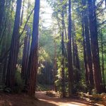
 I’ve been visiting the Mount Shasta Area of Shasta-Trinity and Klamath National Forest my whole life, even before I became paralyzed and started wheelchair traveling. The Shasta-Trinity National Forest and Klamath National Forest are some of Northern California’s pristine outdoor spaces, protected and preserved for future generations.
Past San Francisco and Sacramento, the land opens up, stretching from the Pacific Ocean to the Sierra Mountains with Highway 5 and train tracks running in between. About an hour past Lassen National Park (north of Redding) to the end of Mount Shasta City is the Shasta-Trinity National Forest. Beyond this point is Mount Shasta in the Klamath National Forest (about an hour from Ashland, Oregon).
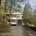
Planning Tips: Have an accessible vehicle to get around and explore this area. When planning your day make sure to have a full tank of gas, water, and a packed lunch. Mosquitos and small flies can also be a bother, especially at certain times of the year, so bug repellant is a good idea. In the peak of summer, temperatures can be over 100 degrees, and in the winter it snows.


Mount Shasta Area (Shasta-Trinity National Forest)
- Shasta Caverns National Natural Landmark has boat tours. When not heavily populated with tourists, wheelchairs can take the long ramp down to the boat dock and wheel right onto the boat. The tour’s main attraction is the caves, which are not accessible due to stairs, but the boat ride is possible. Right near the designated parking spots, there is a kids’ rock panning and mining setup, which is accessible. The visitor center has a gift shop and toilets. Bailey’s Cove has a nice picnic area and a long, paved dock down to the lake that makes for a nice trail. Packer’s Bay is a marina with different views of Lake Shasta.
- Shasta Dam near Shasta Lake has a large visitor center along with a picnic area and a paved pathway across the actual dam.
- Siskiyou Lake Trail Loop and Wagon Creek Pedestrian Bridge is a scenic spot and a great viewpoint of Lake Siskiyou. The trail is a mix of dirt hard pack, pine needles, and gravel with some short, paved sections. Mobility devices with wide mountain bike-type tires and all-terrain rolling walkers should be fine. The trail is used by hikers, dog walkers, runners, and horses, so be alert. Some pre-planning may be required to pick your best route. Do try the Wagon Creek Bridge for photo opportunities. The two pontoon bridges at the north end of the lake are in place from mid-May to mid-November. I don’t know if these are wheelchair accessible. At other times of the year, the distance one way on the north shore to the delta is 2.2 miles and the distance following the southwest shoreline is 4.4 miles to the delta.
- Mt. Shasta City Park is in the heart of the downtown area. A paved pathway loops around an open grass field and a playground. What’s particularly special is a natural spring coming out of the mountain that is suggested to be the head of the Sacramento River, as discovered by John Muir. People pour in and out daily to fill up jugs of water. A sign advises not to drink the water as it has not been tested and approved as safe, but that doesn’t stop people.
- Sisson Meadow Trail: Located in the heart of downtown Mt. Shasta City, this trail loops around a beautiful meadow with great views of Mt. Shasta and the surrounding mountains. The short 1/4 mile trail is a mix of pavement and boardwalk with a low border and a few benches along the way. The boardwalk portion of the trail may be too narrow for some larger wheelchairs.
- Elsa Rupp Preserve Trail: Open March-September. This trail crosses over Big Springs Creek a few times. Some bridges may be too narrow or unsafe to cross by wheelchair. Begin at the Sisson Museum parking lot and go past the displays describing the trail. Alternatively, take North Old Stage Road about 1/4 mile and make a right into a small gravel parking area. The trailhead is located by a stone monument.
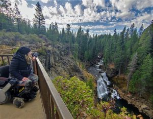
- McCloud Waterfalls: The Upper, Middle, and Lower viewpoints to the falls are barrier-free and accessible for most. The trail at the Lower and Upper Falls is paved, while the middle falls is a firmly-packed natural terrain. The Middle Falls has the most designated handicapped parking; Upper Falls has one spot. Lower Falls has a very nice ADA picnic area whereas Upper Falls has only one picnic table. The viewing area of the Lower Falls is very popular with photographers and painters. There is a paved trail that travels to the Fowler Campground, where there are accessible campsites.
- McCloud Great Shasta Rail Trail: Not officially wheelchair accessible, but maybe for some at least partially. There’s no border of any kind, but there is a wide, packed-dirt trail. Hiking on the wooden tracks themselves is required at some point and may be problematic and unsafe for many wheelchairs.
- Dunsmuir Park and Botanical Gardens: Just south of Lake Shasta along Highway 5 and the Sacramento River, featuring a lovely small park with a playground and seasonal garden.
- Tauhindauli Park (Dunsmuir): A dog-friendly, paved, looped trail, located under the bridge and along the river. A portion of the trail veers directly to the river with a good paved platform.
- Castle Crags State Park: Two officially accessible trails are the Vista Trail and the Root Creek Trail. Both trails are located near one another and at the top of the mountain up a windy two-way, single-lane road. The two trails are firmly packed dirt and are wide enough for a wheelchair; no handrails are along this trail. An accessible vaulted toilet is also in the area.
- McArthur–Burney Falls Memorial State Park: Three areas to check out at this park. Designated accessible parking spots, bathrooms, and a picnic area are located near the falls overlook. A short paved pathway leads to the overlook area of Burney Falls. The Headwaters Trail is a 0.71-mile, one-way trail that meanders upstream along Burney Creek and passes an accessible fishing pier. This trail makeup is crushed, packed rock and dirt, and is relatively flat, except for a few small inclines of about 10 degrees. One water barge, to help with overflow, may be challenging for some wheelchair users to hike over. Furthermore, the Burney Creek Trail has designated parking and an accessible vaulted toilet at the Lake Britton Beach trailhead, and the one-way dirt trail is barrier-free for the first 1.25 miles or so. A fishing pier is accessible at this trailhead along with a beach wheelchair to rent. The Pioneer Cemetery Trail Trailhead has limited parking near campsite #75 in the Pioneer Campground. The trail itself is firmly packed and barrier-free but is a little rocky, which may be challenging for some wheelchair hikers.
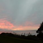
Sunset Spots
- Spring Hill Road
- Castle Lake Road
- Shasta Wildlife Refuge
Places to Stay
- Inn at Mt. Shasta (Mt. Shasta City)
- LOGE (Mt. Shasta City)
- Inn at Shasta Lake (Shasta Lake)
- Cabins @ Burney Falls: Two accessible cabins (#59 & #62) are available in the Rim Campground. Inside, the cabins are equipped with heat and two single beds with foam mats, but no electricity. Outside, each cabin has its own fire pit, picnic table, and space for a tent. Accessible restrooms/showers and parking are available in the campground loop. Phone (530) 335-2777 for more information.
Food + Drinks
- Berryvale Grocery Store (Mt. Shasta City): Quality grocery market located in the heart of downtown with gourmet, organic, and regular items. A café is also located inside in the back and is a favorite among locals
- Thrive Bar (Mt. Shasta City): Best known for their kombucha on tap, but also serves other organic drinks along with coffee and tea. (No alcohol.)
- Café Maddalena: Best food in Mt. Shasta City.
- Pizza Factory and Old Mill BBQ: Located not far from Shasta Lake, and they deliver.
- The BASSHOLE BREWS is a nice restaurant with a rich, established history near Shasta Lake.
South of Mount Shasta (Shasta-Trinity National Forest)
Whiskeytown National Recreation Area is about an hour south of Lake Shasta. The Kennedy Memorial Highway is particularly scenic, and nearby is the visitor center with wheelchair accessible flush toilets, views of Whiskeytown Lake, and partial access to a picnic table on a paved platform. The best picnic area is at Brandy Creek Beach with a paved path leading from the parking lot to two tables near the water. This paved path continues up the creek along more picnic tables and trees. A small general store with some snacks and basic supplies is near the parking lot and flush toilets.
There are two wheelchair accessible fishing piers at Whiskey Creek and Oak Bottom in the Whiskeytown National Recreation Area. Accessible docks to launch boats are also at these two locations. The Guardian Rock Trail is wheelchair accessible with a 0.25-mile paved pathway that leads to an overlook. The one-way trail is flat. The trailhead along with an accessible vaulted toilet is at Horse Camp. The Crystal Creek Falls Trail is also wheelchair accessible. It’s 0.5-miles, paved, and flat, and leads to a pool of cascading waters. This area is a local favorite, especially when the weather is hot. The road to the trailhead is a bit long, but once there, find one handicapped parking spot next to an accessible vaulted toilet. Near the end of the trail, a few picnic regular tables are on a dirt surface.
More Stuff:
- Sacramento River Trail at Sundial Bridge.
- Sacramento River Trail Through Caldwell and Lake Redding Parks
- South Sacramento River Trail Head, off North Court Street.
- Sacramento River Trail (north section) Behind the Elks and Lake Redding Estates
- Turtle Bay East Open Space; at the north end of North Bechelli Lane
- Clover Creek Preserve. Off Shasta View Drive south of Highway 44
- Lema Ranch Trail System off Shasta View Drive
- Sacramento River Rail Trail off Iron Mt. Road
- Palisades Trail at the end of Palisades Avenue off Hilltop Drive
- John Reginato River Access is located at the South Bonnyview Bridge off South Bonnyview Road and has been modified with accessible parking, restrooms, and a platform over the river.
North of Mt. Shasta (Klamath National Forest)
- Mt. Shasta Vista Point: Off Highway 89, before reaching Highway 5, stop at this viewpoint for some photos of Mt. Shasta. One accessible parking spot leads to a ramp and paved viewing platform.
- Greenhorn Park Trail: Located just outside the city of Yreka, and is a lovely spot loved by locals, especially in the spring and fall. The trail around Greenhorn Reservoir is wheelchair accessible with a hard-packed dirt surface, and some of the other trails may be wheelchair accessible enough for some hikers. Greenhorn Park also has an accessible fishing platform.
- Kangaroo Lake is a campground and day-use area beside a beautiful high mountain lake that can usually be accessed by vehicle during the months of May-October. Wheelchair accessible features include 2 fully accessible campsites, bathrooms, a paved trail down to the lake including a concrete ramp down to the lake’s edge, and a fishing platform. This area has great fishing and is very popular.
- Taylor Lake Trailhead: Wheelchair access into the wilderness is VERY uncommon but at Taylor Lake Trailhead it’s possible. The road is partly paved going up to the trailhead and the parking lot is paved with an accessible vault toilet. The trail surface is hard-packed dirt that has a very gentle slope but some roots may be hard to get over without some assistance. The trail ends at a grassy meadow at the edge of the lake. Camping, fishing, and day use are allowed here and the road is generally snow free from June-October.
- Juanita Lake is a developed campground and day-use area with a paved trail that circles the lake. There are accessible fishing platforms, bathrooms, picnic tables, and campsites. It’s a great place to camp or spend a few hours fishing during the summer or fall.
- Tree of Heaven is a campground and popular river access. The campground has hard-packed surfaces and an accessible toilet. Near the river, there is a paved trail with a concrete ramp to the river. There is year-round access.
- Siskiyou Crest/Mount Ashland: The scenic drive west of Mount Ashland Ski Park on Forest Service Road 20 is a beautiful way to experience a piece of the Pacific Crest Trail (a trail running through California, Oregon, and Washington from the Mexican border to the Canadian border) all from your vehicle. The road follows the ridge line and the views are superb. Wildflowers are abundant from late June into July. A picnic area called Grouse Gap Shelter can be found a few miles west of the Ski Park. The parking area is hard-packed dirt and the shelter is open on two sides and has a concrete floor. Generally, the road opens up in late June and is open through October. The road up to Mount Ashland is a two-lane highway, after that, the road is unpaved and narrow. A high-clearance vehicle is suggested if you want to drive past the Grouse Gap Shelter, as the road becomes rough at times but a passenger vehicle is fine if you are just headed to the shelter.
Last updated on July 8, 2023